


3.-Path of the Wall PR-A126
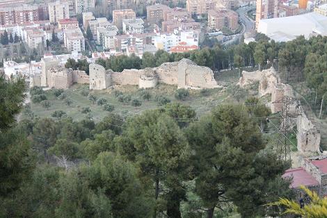
It is a circular route starting in the town centre of Jaén, specifically in the ring road (Carretera de Circunvalación), in front of the number 126. It is a path in good condition, close to an electric transformer, which climbs the northern side of the hill of Santa Catalina. The route begins on a steep slope, but later, when it turns right, it gradually becomes flatter when crossing the wall of the castle. After crossing the wall, we find an olive grove, then the trail forks. We will return to this point in our descent because here is where the circular path of our tour starts. Then we turn to the right, bordering the olive grove. From this plain area you can see San Vicente de Paúl Quarter (below), and La Magdalena and San Juan Quarter at the right. When we reach the pine grove, we continue along our path descending some metres; later we go up the path crossing the pine forest. 150 metres from there we find a crossroad where we should turn right. A little further ahead, we can see a fence with an open gate, our path crosses that fence and leaves through another similar gate. Both of them are usually open.
Continuing along the path, in front of us we can see the lane of Fuente La Zarza, placed above us. Here, the forest opens leading into an olive grove. If we turn left, we can see a narrow path climbing the slope diagonally towards the right side of the pine grove, which is located next to the olive grove. The path here begins to ascend gradually. Our path is connected to a lane which leads to another olive grove. At this point, we walk uphill to the left through a steep stretch that lead us, by a footpath and finally by a tarmac, to the Neveral Hospital.
Due to the construction works near the hospital and the absence of an appropriate path (in the past one path bordered the hospital), it is easier to continue straight on through the asphalted road crossing the Dr Sagaz Neveral hospital ground. Now we arrive to the road and in order to avoid the car traffic we continue on the path of the Neveral’s recreational area. Now, we take a narrow pathway placed over a basketball court which crosses the forest trail, (common section with PR-A127: Pinares del Neveral). The route continues close to the valley and again it crosses toward the road. In 50 metres, approximately, we find Caño Quebrado Centre, which is the only fountain that we find in that area. (End of the common section with PR-A127 Pinares del Neveral).
Caño Quebrado joins Jaén’s road, Santa Catalina Castle’s road and Nacional Parador road with the road of Neveral Hospital that was mentioned above. In front of Caño Quebrado’s Fountain. The leftt side of the road ascends to the Castle of Santa Catalina and the Parador. We must take the lane that descends close to some old chalets (country houses), then turn right through a path surrounded by pine trees that leads us to the crossroad next to the wall, returning again to our starting point.


At the moment there are no defined events.
![]()