


6.-Cruz de la Chimba Path
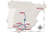
It is located in Cañada de las Azadillas, a natural area in the peri-urban park of Jaén, 18, 5 km outside of the city. The forest and the rugged terrain are areas of breathtaking beauty that are well worth visiting. The place has remained practically unchanged because it is located in an isolated area. In this beautiful place we find a recreational area, which is very popular for the inhabitants of the city, but also for the people living in the nearby towns. Every weekend lots of people come to this natural site in order to have picnics, to hike, etc. There is also a Nature Room with an Environmental Education program. We can access this place from the Alcantarilla quarter, from the local road JA-3210 to Puente de la Sierra. Then, we turn right on the road towards the Quiebrajano swamp, Otiñar and Cañada de las Azadillas. At kilometre 14, below the Otiñar Castle, we take the left road which crosses a bridge, and after approximately 3 km, we reach Cañada de las Azadillas.
The path begins in Cañada de las Azadillas’s Fountain, near to this, we find a little roundabout where the asphalt road ends. Now, we turn to the right of the fountain, where we find a valley. We ascend about 80 metres up the road. We turn 90 º to the right to find a bridle path that crosses the fountain’s slope. The path is well-marked, we can find some fallen trees on our way, but in general it is easy to avoid them.
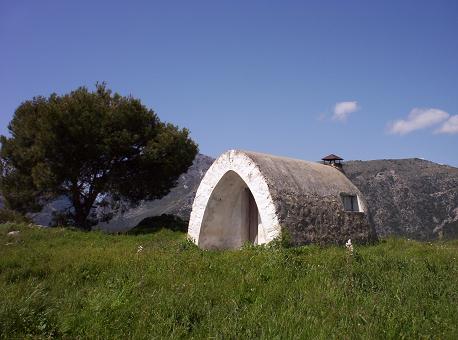
The first stretch ascends by a well-marked path, which makes the climb easier. As the altitude increases, we may find some bushes in our way, but they do not obstruct the trails or marks. In the upper stretch of the trail, the gradient is gentle. Near to this, we find an open terrain with the remains of an old lane (not very well marked) that leads to an open area where the asphalt trail begins and where the forestry vehicles change their direction. This point marks the start of the trail and we should return later if we want to visit the Forest House “Cruz de la Chimba”, which is 200 metres away. It is hidden in the dense pine trees. There is no marked path, so it is easy to become confused although it is a short distance. The best option is to walk on the asphalt trail about 20 metres from the beginning of the trail (where vehicles are allowed), perpendicularly to the lane and on the right of the trail (westerly direction, course 247º). Through the pine grove, we enter an area with a path (not very well marked), in which you can find the traces left by people using it. It ascends until we arrive to a valley where the Forest house is located.
Chimba’s Cross. It is the key place of the trail. It has great panoramic views of Jaén’s Mountain range. Behind the Forestry House, we find La Pandera. Below this, is the Valley of Quiebrajano River, to the North is Otiñar’s Castle and Jaén can be seen in the distance. The cross remains intact and close to its original state thanks to the respectful care of the visitors. Special care should be taken if we are with children or if someone has vertigo, because the Forestry House is located in a rugged area with no protection.
We return to the forest trail following the same route. Again on this trail, we turn to the right, where the terrain is flat. This area is known as Los Llanos de Navalopos. The trail is easy to follow. To the left, it crosses a plain and later it borders another plain, which ascends until we reach a hill. At this point, the trail descends until we return to Cañada de Las Azadillas. Before we arrive to Cañada, we find a vehicle barrier and a little further ahead we find a crossroad that links Cañada de las Azadillas with Llanos de Palomares and the town of Carchelejo. We continue descending on the left towards Cañada de las Azadillas. We have reached the end of our trail when we arrive to the Nature Room.
INFORMATION ABOUT THE PATH:
Distance: 6.9 km.
Expected time: 2 hours
Minimum altitude: 1114 m
Minimum altitude: 931 m
Difference in altitude: 283 m
Vegetation type: Aleppo pine
Conservation status: Well-marked trail
Interesting information: Due to the latest rain and snow, there are some fallen trees on the trail but it is not difficult to avoid them.
Attendance: Low (weekends)
Difficulty level: Average
Environment: Forest
Usage: Hiking, it is possible to do it in MTB in the opposite direction, until we reach the end of the trail
Public infrastructure:
- Cañada de las Azadillas Recreational Area
- Cañada de las Azadillas Fountain (at the beginning of the trail) Non-potable water
- Cañada de las Azadillas Nature Room
Starting point Access:
18.5 km far from the city of Jaén, this area is very popular due to its recreational area. A vehicle is necessary to reach the starting point.
Take the local road towards Puente de la Sierra JA-3210
At km.14, we turn right on the road towards the Quiebrajano swamp, Otiñar and Cañada de las Azadillas. At kilometre 14, below the Otiñar Castle, we take the left road which crosses a bridge, and after approximately 3 km, we reach Cañada de las Azadillas.
The trail begins in Cañada de las Azadillas’s Fountain; near to this, we find a little roundabout where the asphalt road ends
Cartography: Map sheet 969-I E=1: 25. 000 National Topographic Map: National Geographic Information Centre


At the moment there are no defined events.
![]()